• Hallo Gast, wir suchen den Renner der Woche 🚴 - vielleicht hast du ein passendes Rennrad in deiner Garage? Alle Infos

Aktuelles Kartenmaterial für Wahoo ELEMNT BOLT, ROAM, ELEMNT selbst generieren

first of all, thank you for your help! :)

I see what you mean with the difference between the v1 and v2 colors. You still might want to try a custom theme, the color settings are pretty different from the Wahoo ones.
korrectly
You might be able to get a good start to what you want by just removing a couple of sections that add the colored area's to the map from the v2 theme like:
Code:
    <m e="way" k="natural" v="wood|scrub">
        <area cat="bolt2" src="patterns/light_green.png" />
        <area cat="bolt2-dark" src="patterns/dark_green.png" />
        <area cat="roam2" src="patterns/light_green.png" />
        <area cat="roam2-dark" src="patterns/dark_green.png" />
    </m>
Removing those sections would result in a white background with only the roads/paths rendered.
To use it, create a folder vtm-elemnt in the maps folder on your roam and put the edited vtm-elemnt.xml there.
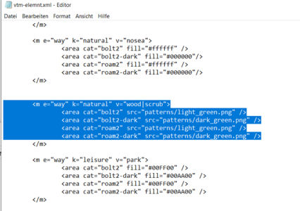
I don't know anything about programming. But to delete a few lines is no Problem. Do you think I should delete the marked lines completely so that the background is white?
 

Anhänge

  • Screenshot_Editor.png
    Screenshot_Editor.png
    101,9 KB · Aufrufe: 23
Die eine Zeile unter Deiner Markierung musst Du mitlöschen, denn erst </m> beendet die darüber liegenden Zeilen, die mit <m … beginnen.

Oder anstatt löschen die gewünschten Zeilen einzeln zeilenweise oder im Block auskommentieren:
<! ZEILE ODER BLOCK >
 
Die eine Zeile unter Deiner Markierung musst Du mitlöschen, denn erst </m> beendet die darüber liegenden Zeilen, die mit <m … beginnen.

Oder anstatt löschen die gewünschten Zeilen einzeln zeilenweise oder im Block auskommentieren:
<! ZEILE ODER BLOCK >
cool! danke
 
Oder anstatt löschen die gewünschten Zeilen einzeln zeilenweise oder im Block auskommentieren:
<! ZEILE ODER BLOCK >
wenn ich so drüber nachdenke wäre das auskommentieren die bessere Lösung wenn man mit dem Ergebnis nicht zufrieden ist. >>> so korrekt:?

<!-- <m e="way" k="natural" v="wood|scrub">
<area cat="bolt2" src="patterns/light_green.png" />
<area cat="bolt2-dark" src="patterns/dark_green.png" />
<area cat="roam2" src="patterns/light_green.png" />
<area cat="roam2-dark" src="patterns/dark_green.png" />
</m> -->

oder

<!m e="way" k="natural" v="wood|scrub">
<area cat="bolt2" src="patterns/light_green.png" />
<area cat="bolt2-dark" src="patterns/dark_green.png" />
<area cat="roam2" src="patterns/light_green.png" />
<area cat="roam2-dark" src="patterns/dark_green.png" />
</m>

Ich sag ja ich bin totaler Laie in dem Thema 🫣
 
First one to comment out.
With a little luck I can post a cleaned up version this evening. Without land use and black and white roads/tracks except main roads in yellow and motorways in red.
 
Weiß jemand, wie man die Linien für den bereits gefahrenen Track sowie für geplante Route und 'Umleitung'/Navigation zurück zum Track verändern kann?
 
Weiß jemand, wie man die Linien für den bereits gefahrenen Track sowie für geplante Route und 'Umleitung'/Navigation zurück zum Track verändern kann?
das ist auch so ein Thema :mad: Wenn der Track verlassen wird, ändert sich die Tracklinie in einen feine graue Linie die nur schwer zu erkennen ist. Ungeachtet ob die Umleitung aktiv ist oder nicht.
Eine gelbe Tracklinie anstelle der grauen würde ich feiern.

@Ebe66 what do you think? Is that possible?
 
Weiß jemand, wie man die Linien für den bereits gefahrenen Track sowie für geplante Route und 'Umleitung'/Navigation zurück zum Track verändern kann?
Has been asked in the Telegram group before. Unfortunately not possible, those colors/styles are embedded in the firmware according to our guru on telegram.
 
Has been asked in the Telegram group before. Unfortunately not possible, those colors/styles are embedded in the firmware according to our guru on telegram.
Thanks!

@macdet Bei weiterem Nachdenken über deine Nachfrage zu track=grade1 fiel mir ein, warum ich die Linie dafür bisher sehr schmal gehalten hatte: Sie würde sonst der durchgezogenen schwarzen Linie der bereits gefahrenen Strecke sehr ähnlich sehen. Die würde ich eigentlich auch gerne anders darstellen (bspw. gepunktet oder so), das scheint aber nicht zu gehen.
 

Anhänge

At first everything was great, but when I turned off the road onto the dirt roads, trails and gravel roads I realized that these paths were missing ;-)
Hier ist Rennrad-Forum, also gaaaanz dünnes Eis… :D

Im Ernst: dann brauchst Du ein Theme, was auch die unbefestigten Wege anspricht und darstellt. Bei meinem Theme habe ich sie auch absichtlich „gelöscht“.
 
Hier ist Rennrad-Forum, also gaaaanz dünnes Eis… :D

Im Ernst: dann brauchst Du ein Theme, was auch die unbefestigten Wege anspricht und darstellt. Bei meinem Theme habe ich sie auch absichtlich „gelöscht“.
🤣🤣 ich gebe zu mein RR ist auf dem Smartrainer festoxydiert und mit dem GRVL ist dann die Versuchung dann doch zu groß in die Botanik abzubiegen.
Das Theme hat mich an meine alten Tage erinnert, als ich mit dem Forerunner 305 (Brotkasten) die Brotkrümelnavigation gefeiert habe 🙃
 
If you share some gps coordinates I can have a look on my computer. If the Wahoo original theme shows the paths I can try and make it work. But to be honest, I'm not planning to create a whole custom theme for this.
I just tried it again with cruiser and it seems to show every dirt/gravel etc path I know in my region, even mtb tracks.
Something else to consider, what is your map source? If a track is not in the map it will not show up either of course.
Have a look at my Strava activity from KM 31 to KM 54 the gravel part is the biggest and the forest paths are mostly not visible

https://www.strava.com/activities/11336524500

I planned the route via Komoot
 
Zurück